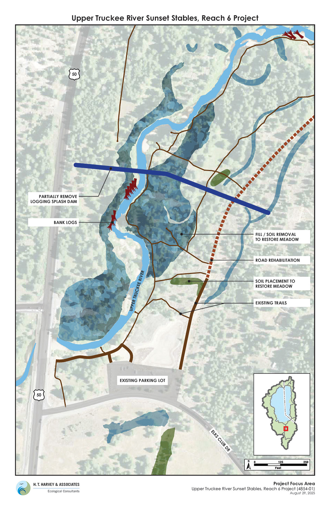
Upper Truckee River Sunset Stables, Reach 6 Project
Project Details
LEAD AGENCY
California Tahoe Conservancy
FUNDING PARTNERS
California Tahoe Conservancy / USDA Forest Service, Lake Tahoe Basin Management Unit
LOCATION
Help Protect Tahoe
Help protect Lake Tahoe’s clear blue waters, mountain forests, and world-class recreation by ordering your Tahoe Plate today.
Get Your Tahoe Plate
Overview
The California Tahoe Conservancy is in project planning and development for the Upper Truckee River Sunset Stables, Reach 6 Project (Reach 6 Project), which includes habitat restoration with conifer removal on Conservancy land south of the Lake Tahoe Airport. The Conservancy wants to hear from you as staff plans the project. Join a site walk or email us your comments. See details below.
Public Invited to Provide Project Comments to Conservancy Staff
In early September, the Conservancy hosted two public site walks to present concepts, take questions, and hear comments on the Reach 6 Project. Members of the public can continue to provide comments and send questions to Scott Carroll, scott.carroll@tahoe.ca.gov.
History
In 1999, the Conservancy acquired the Sunset Stables property, which is located along the Upper Truckee River and floodplain. The Conservancy and USDA Forest Service, Lake Tahoe Basin Management Unit (LTBMU) planned restoration work in this area in the early 2000s through 2012. In 2017, the LTBMU completed a restoration project, known as Reach 5, on federal lands and part of the Conservancy’s Sunset Stables property.
The Conservancy restarted the Reach 6 project in 2024. The study area is primarily the former Sunset Stables property but also includes Conservancy properties in the Meadowvale area south of Elks Club Drive. The project goals are to restore wetlands, improve water quality, enhance aquatic and terrestrial wildlife habitat, and increase resilience to climate change. The Conservancy recognizes that public property in the area is important for public access and recreation. The Conservancy will close certain areas during project implementation but will look to maintain as much public access as possible during this time.
The Conservancy recently completed technical analysis and preliminary engineering and proposes the following restoration actions as part of the Reach 6 project:
- Removing encroached conifer trees from the meadow,
- Excavating fill and lowering areas of the floodplain,
- Installing logs and vegetation on the riverbanks,
- Redirecting stormwater flows into meadows, and
- Restoring the former stables site.
This project complements recent work at the former Elks Club site on Conservancy land. El Dorado County, as part of its Country Club Heights Project, removed fill from wetlands, constructed a storm water basin to improve water quality, and built new trails to the river. In summer and fall of 2025, the Conservancy is completing a project to reconstruct the parking lot to improve water quality and accessibility.
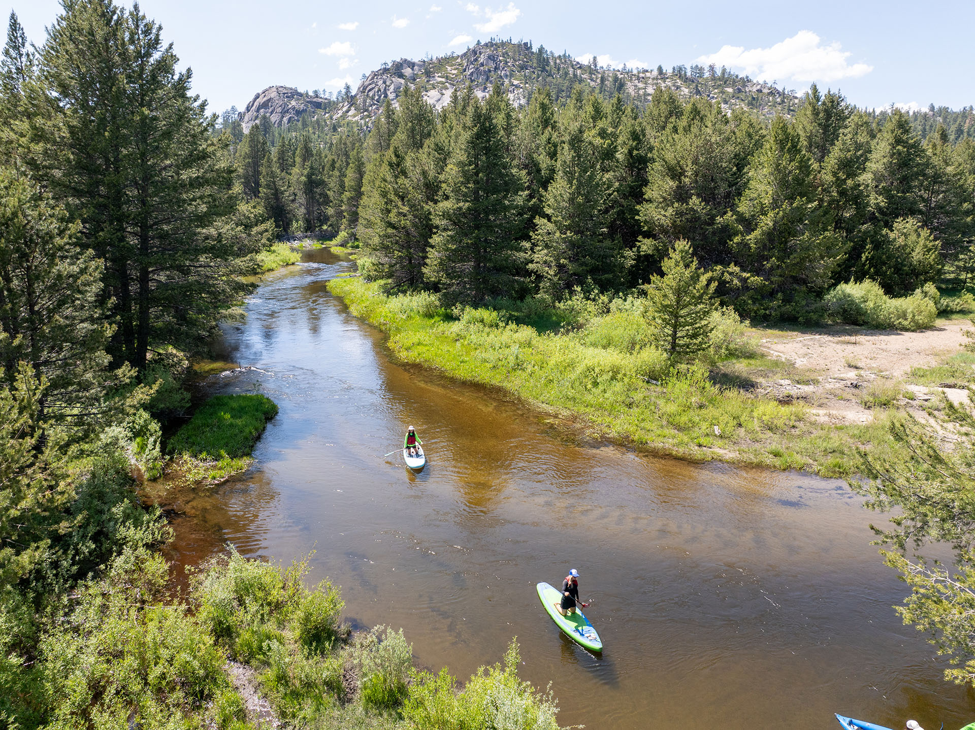
Restoring the Upper Truckee River
The Upper Truckee River collects runoff from a third of the land in the Lake Tahoe Basin and supports some of the largest wetlands in the Sierra Nevada. Historical logging, grazing, and urban development have degraded the river. Along with the Conservancy’s Tahoe Pines property in Meyers, the Conservancy and its partners have now protected most of the lower nine miles of the river. As an example, in 2022 the Conservancy completed the Upper Truckee Marsh Restoration Project, which enhanced and restored 250 acres of wetlands where the river meets Lake Tahoe.
Project Planning Maps


Sunset Stables, Reach 6 Images